1996 Flood in Rainier, Oregon
 |
| Photo by Cliff West |
In February 1996, the state of Oregon experienced one of its greatest floods. Sudden warming and rain following a cold winter storm resulted in massive amounts of melting snow and ice overflowing the creeks and rivers, leading to widespread flooding. My dad took these pictures in Rainier, Oregon, during the height of the flooding.
 |
| Photo by Cliff West |
These first two pictures show chunks of ice floating down the Columbia River. This is very unusual, as the Columbia River does not freeze. This ice has been washed down from the mountains so quickly that is has not had time to melt before reaching the river.
 |
| Photo by Cliff West |
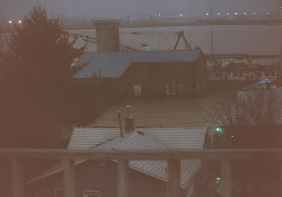
This late evening picture show how much the water has risen. It is almost to the bottom of the Norris dock, far above the river's normal high-water mark. Comparing the rigging of the vessels to the previous picture will illustrate how much the water has risen.
 |
| Photo by Cliff West |
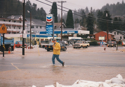
In downtown Rainier, Fox Creek flowed over U.S. Highway 30. Sandbags have been placed in the parking lot of the Rainier Shopping Center to protect the building from the floodwater.
 |
| Photo by Cliff West |
Fox Creek exited an inadequate culvert at this point. The culvert is completely submerged, resulting in the creek backing up and flooding.
 |
| Photo by Cliff West |
Though the open creek bed seems to still have some capacity here, that is only because the surrounding land slopes away from U.S. Highway 30.
 |
| Photo by Cliff West |
This view from the railroad trestle over Fox Creek illustrates the situation better.
 |
| Photo by Cliff West |
This view is from the same location but looking in the other direction toward the Columbia River, which has backed up to the creek. The creek is actually in another inadequate culvert here as well, which is now completely under water.
 |
| Photo by Cliff West |
Floodwater surrounded Rainier Riverfront Park. The culvert began at this path leading into the park.
 |
| Photo by Cliff West |
The floodwater was up to the bottom of the railroad trestle over Fox Creek.
 |
| Photo by Cliff West |
At this point, the floodwater was very close to spilling into Rainier Riverfront Park.
 |
| Photo by Cliff West |
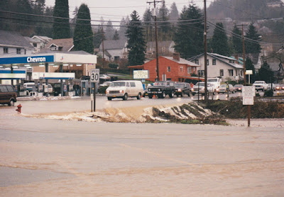
The parking lot of the Rainier Shopping Center was sandbagged against the water from Fox Creek that was flooding across U.S. Highway 30, but there was also floodwater backing up at the rear corner of the parking lot as well.
 |
| Photo by Cliff West |
From this view, the sandbags appear to have been only partially successful, but the situation would have probably been much worse without them. I imagine that the water from the creek flooding across the highway was the more pressing concern, and the sandbags do appear to be keeping it at bay.
 |
| Photo by Cliff West |
The playground and field at Rainier Elementary School were completely flooded. The Fox Creek culvert went under the field. The doors to the school gymnasium were sandbagged in an attempt to protect the wooden floor.
 |
| Photo by Cliff West |
Due to the inadequate culvert, Fox Creek actually flooded the field often, though never to this extreme degree. The culvert began just beyond the fence.
 |
| Photo by Cliff West |
The lowest point of West C Street passed directly over the culvert, and the flooding made the street impassible.
 |
| Photo by Cliff West |
The intersection of West 2nd Street and West D Street was also completely underwater. The small trees poking up out of the water marked the boundary between the school's field and West 2nd Street.
 |
| Photo by Cliff West |
The rear storage lot of the Rainier RV Center was completely flooded, leaving vehicles under water.
 |
| Photo by Cliff West |
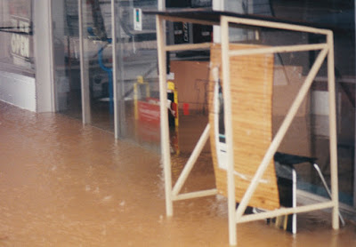
The front of the Rainier RV Center was also flooded.
 |
| Photo by Cliff West |
In my next post, I will show the aftermath of the flood, with pictures that I took myself.


No comments:
Post a Comment