Wednesday, February 28, 2018

1992 California Trip: Shrine Drive-Thru Tree Auto Park

Photo by Cliff West

The next stop on my family's 1992 California trip was the Shrine Drive-Thru Tree Auto Park in Myers Flat, California. Unlike other drive-through trees, the opening in the Shrine Drive-Thru Tree is natural, created by fire long ago (though it has been widened over the years as vehicles increased in size).

Photo by Cliff West

The trunk of the Shrine Drive-Through Tree was completely hollowed out by the fire and left an opening at the top, as shown by this view looking up from inside the tree.

Photo by Cliff West

The Shrine Drive-Thru Tree is 5,000 years old. It is 275 feet high and has a diameter of 21 feet and a circumference of 64 feet.

Photo by Cliff West

Another interesting feature of the Shrine Drive-Thru Tree Auto Park is the Tree House Village with two-story "tree houses" made of hollowed out redwood tree trunks.

1992 California Trip: Famous One-Log House

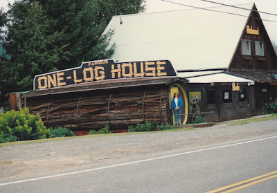
Famous One-Log House in Phillipsville, California, on March 19, 1992
Photo by Cliff West

While our family was in Phillipsville, California, on our 1992 California trip, we also saw the Famous One-Log House. It was closed, but my dad took this picture of my mom in front of it. The Famous One-Log House was created by Art Schmock in 1946 from a single 42-ton redwood log from a tree that was over 2,100 years old. It took two men eight months to hollow out a room 32 feet long by 7 feet high. It was initially intended to tour the country, but due to its size it spent 25 years in Cummings, California, before being moved to Phillipsville. In 1999 it was moved once again, to Garberville, California.

1992 California Trip: The Living Chimney Tree

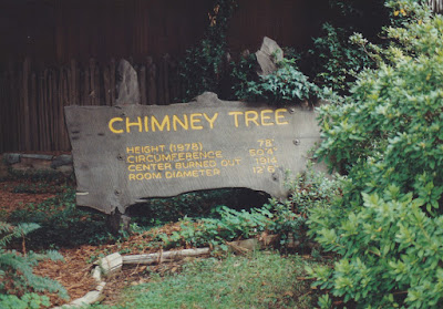
The Living Chimney Tree in Phillipsville, California, on March 19, 1992
Photo by Cliff West
On our family's 1992 California Trip, we left Leggett on March 19, 1992, and continued north. We stopped briefly in Phillipsville, CA, home of the Living Chimney Tree. The Living Chimney Tree is a California coast redwood tree that was hollowed out by a fire, but is still alive.

The Living Chimney Tree in Phillipsville, California, on March 19, 1992
Photo by Cliff West

The Living Chimney Tree is 78 feet tall (as of 1978) and has a circumference of 50 feet, 4 inches. The center was burned out of the tree in 1914, leaving a "room" 12 feet, 6 inches in diameter.

The Living Chimney Tree in Phillipsville, California, on March 19, 1992
Photo by Cliff West
This is a view from the inside of the Living Chimney Tree looking up, showing the opening in the trunk that makes the tree a "chimney."

1992 California Trip: Chandelier Drive-Thru Tree

Chandelier Drive-Thru Tree in Leggett, California, on March 18, 1992

On our family trip to California, after riding the California Western Railroad from Fort Bragg to Willits and back on March 18, 1992, we continued on our way, even though I wanted to spend another night in the nice motel in Fort Bragg.

We ended up spending the night in the tiny town of Leggett, home of the Chandelier (Drive-Thru) Tree, which we drove through as it was getting dark, as this picture I took shows. The Chandelier Tree is a California coast redwood tree. It measures 315 feet tall and 21 feet wide and is about 2,400 years old. The opening was cut in 1936 or 1937.

The entire town of Leggett, consisting of a motel, café and shuttered gas station, was for sale.

1992 California Trip: California Western Railroad

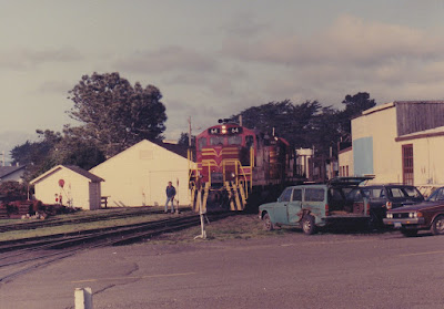
California Western GP9R #64 at Fort Bragg, California, on March 17, 1992
Photo by Cliff West

On our family's California trip, we arrived in Fort Bragg on the afternoon of March 17, 1992. Due to our unscheduled exploration of The Geysers, we were too late to ride the California Western Railroad to Willits, so we spent the night in Fort Bragg. Our motel in Fort Bragg was the best we stayed in during the entire trip. It was a fairly new motel with an indoor swimming pool. Meanwhile, my dad went down to the California Western depot and got these pictures of a California Western freight train arriving in Fort Bragg.

The California Western Railroad was originally built in 1885 by the Fort Bragg Lumber Company as the Fort Bragg Railroad. In 1904, passenger service was inaugurated. On July 1, 1905, the railroad was renamed the California Western Railroad & Navigation Company. The railroad was completed to Willits and a connection with the Northwestern Pacific Railroad on December 11, 1911. Self-propelled gas-powered railcars were added for passenger service in 1925, they were nicknamed "skunks" because of the smell of their exhaust. The "skunks" soon took over passenger service, and regular steam-powered passenger train service ended in November 1929.  On December 19, 1947, the name was shortened to California Western Railroad. In June 1987, the California Western was sold to Kyle Railways.

California Western GP9R #64 at Fort Bragg, California, on March 17, 1992
Photo by Cliff West

California Western GP9R #64 was originally built by the Electro-Motive Division of General Motors in January 1955 as Southern Pacific #5607. In 1965 it was renumbered to #3444. It was rebuilt at Southern Pacific's Sacramento General Shops to GP9R #3311 on May 11, 1970. It was retired by Southern Pacific on December 17, 1986 and sold to Metal Processing, Inc. in Vinton, Texas on January 2, 1988. It was resold later that year to Kyle Railways as #1750, and was transferred to the California Western in May 1989.

The second locomotive is California Western RS11 #62. It was originally built by Alco Products in April 1959 as Southern Pacific #5854. In 1965 it was renumbered to #2919. It was sold to Kyle Railways on January 10, 1980, and was later assigned to the California Western.

California Western M-300 at Fort Bragg, California, on March 18, 1992

The next day, we rode the California Western Railroad’s “Skunk Train” from Fort Bragg to Willits and back. While we waited for departure time, we made a souvenir flatted penny in a machine in the depot. I also got a single-use camera so I could take pictures of the ride. I took this picture of California Western motorcar M-300 waiting in front of the Fort Bragg depot for passengers to board.

Motorcar M-300 is a Motorailer built by American Car & Foundry in 1935 as Seaboard Air Line #2026. It was the third of a group of three built for the Seaboard. It became Aberdeen & Rockfish #106 in 1944 and then became Salt Lake, Garfield & Western MC-3 in 1951. It was purchased by the California Western in 1963.

California Western M-300 at Northspur, California, on March 18, 1992
Photo by Cliff West

Dad took this picture of the front end of motorcar M-300 at Northspur, the midpoint of the line, where the train makes a brief stop. Passengers have the option of remaining in Northspur, where there is a picnic area, and waiting for the train to return from Willits.

California Western M-300 at Northspur, California, on March 18, 1992

Since I took a picture of the front of motorcar M-300 in Fort Bragg, I took this picture of the rear end at Northspur.


Horseshoe Curve on the California Western Railroad on March 18, 1992
Photo by Cliff West

At one point the railroad goes around several horseshoe curves, and another part of the line appears to be a parallel track. My dad took this photo to illustrate it. This is one of the five horseshoe curves with a total length of 6.5 miles required to climb 932 feet between two points 1.5 miles apart.

California Western M-300 approaching Tunnel #2 on March 18, 1992

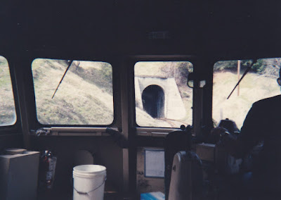
Here is a view from the train I took as it approached Tunnel #2, the second of the two tunnels on the line. This tunnel is 795 feet long and was completed in 1911.

California Western M-300 Engineer on March 18, 1992
Photo by Cliff West

My dad took this picture of the train’s engineer at the controls.

California Western M-300 Interior on March 18, 1992

I took this picture looking back at the interior of motorcar M-300 as we travelled, showing the light passenger load on this March weekday.

Horse along the California Western Railroad on March 18, 1992

Here is a picture I took of a horse I spotted along the line as we approached Willits.

Mendocino County Sheriff's Office Car in Willits, California, on March 18, 1992

As we entered Willits, I spotted this green & white patrol car of the Mendocino County Sheriff's Office stopped at a railroad crossing on California State Route 20 and snapped a picture, as I’d never seen a green & white police car before. At this point the highway crosses Broaddus Creek, which parallels the railroad here.

Arcata & Mad River 44-Tonner #102 at Willits, California, on March 18, 1992
Photo by Cliff West

While the train was turned around in Willits, we had a little time to explore. At Willits, the California Western connected with the Northwestern Pacific Railroad, a subsidiary of the Southern Pacific. There was a variety of railroad equipment in Willits that my dad took the opportunity to photograph. Arcata & Mad River #102 is a General Electric 44-Tonner. It was built in 1950 for the Pine Flat Dam Contractors and was acquired in 1954 by the Arcata & Mad River Railroad, a small shortline that connected to the Northwestern Pacific Railroad at Arcata, California, north of Eureka. The Arcata & Mad River shut down on May 24, 1985, and the abandoned line was sold to the Eureka Southern in 1988. This locomotive was sold to a private owner and was stored in Willits. It has since been scrapped.


Eureka Southern Caboose #51 at Willits, California, on March 18, 1992
Photo by Cliff West

Eureka Southern Caboose #51 is former Southern Pacific caboose #1101. It is a C-40-3 Class Caboose built by SP’s Los Angeles Shops in 1942. The Eureka Southern purchased the northern section of the Northwestern Pacific from the Southern Pacific in 1984, and operated from Eureka to Willits. The Eureka Southern would declare bankruptcy in April 1992, a month after our visit.

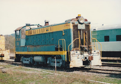
California Western DS-4-4-1000 #53 at Willits, California, on March 18, 1992
Photo by Cliff West

California Western #53 is a DS-4-4-1000 built by the Baldwin Locomotive Works in 1949 as U.S. Army Corps of Engineers W8380. It was later sold to Pan American Engineering and was acquired by the California Western in 1956. It was retired in 1985 and sold to a John Bradley of Laytonville, California, but remained stored in Willits.

Central California Traction S-1 #42 at Willits, California, on March 18, 1992
Photo by Cliff West

Central California Traction #42 is an S-1 that was built by the American Locomotive Company (later called Alco Products) in 1942 as Northern Pacific Terminal Company #34 for use in Portland, Oregon. It was sold to Central California Traction in August 1965. It was retired and sold in March 1983 to a Jim Bruggere who stored it in Willits.

California Western S-12 #57 at Willits, California, on March 18, 1992
Photo by Cliff West

California Western #57 is an S-12 originally built by Baldwin-Lima-Hamilton in September 1953 as Southern Pacific #1541. In 1965 it was renumbered to #2148. It was retired by Southern Pacific on May 24, 1973, and was sold to the California Western on August 9, 1973. The California Western sold it to John Bradley of Laytonville, California, in January 1985. 

Southern Pacific SD9R #4418 at Willits, California, on March 18, 1992
Photo by Cliff West

Southern Pacific SD9R #4418 is wearing the “Kodachrome” paint scheme of the Southern Pacific’s aborted merger with the Atchison, Topeka and Santa Fe. It was originally built by the Electro-Motive Division of General Motors in May 1955 as Southern Pacific #5432. In 1965 it was renumbered to #3910. On November 5, 1976, it was upgraded at Southern Pacific's Sacramento General Shops as SD9R #4418. It was painted in SPSF's "Kodachrome" colors in 1986, and continued to wear them despite the merger being denied by the Interstate Commerce Commission on June 30, 1987, and would continue to wear them to its retirement on September 18, 1995.

Eureka Southern GP38 #30 at Willits, California, on March 18, 1992
Photo by Cliff West

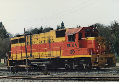
Eureka Southern #30 is a GP38 built by the Electro-Motive Division of General Motors in 1969 as Pennsylvania-Reading Seashore Lines #2007. It was built with dual control stands, and part of the front wall of the cab is extended forward a few inches to make a little more room to walk around the control stand.

Eureka Southern GP38 #30 at Willits, California, on March 18, 1992
Photo by Cliff West

This locomotive became Conrail #7667 before being sold to Eureka Southern in 1984 with three other identical GP38s. All four locomotives would be sold shortly after Eureka Southern’s bankruptcy in April 1992.

California Western M-300 Control Stand at Willits, California, on March 18, 1992

After our train was turned around, we returned to the Willits depot and reboarded for the return trip to Fort Bragg. Here are some pictures I took of motorcar M-300’s control stand while we waited for departure time.

California Western M-300 Control Stand at Willits, California, on March 18, 1992

California Western M-300 Control Stand at Willits, California, on March 18, 1992

California Western M-300 Control Stand at Willits, California, on March 18, 1992

California Western M-300 approaching Tunnel #2 on March 18, 1992

We departed Willits to return to Fort Bragg aboard the train. Here is another view I took as we approached Tunnel #2, this time from the other end.

California Western M-300 approaching Tunnel #2 on March 18, 1992

Here is a view I took from onboard the train as it approached Tunnel #1. The train is on a trestle over the Noyo River right up until it enters the tunnel. The tunnel is 1,100 feet long and was completed in 1893.

California Western Caboose #11 at Fort Bragg, California, on March 18, 1992
Photo by Cliff West

After returning to Fort Bragg, my dad took one last picture of California Western Caboose #11, on static display at the Fort Bragg depot. The plywood-bodied caboose was built in Fort Bragg in the 1960s, on the frame of a former Southern Pacific wood caboose.

Monday, February 19, 2018

1992 California Trip: Point Arena

View from Point Arena Lighthouse
Photo by Cliff West
After exploring The Geysers Geothermal Power Development, our family continued our 1992 California trip by returning to the coast. This picture of a small vessel (probably a commercial fishing boat) was taken from the Point Arena Lighthouse.

View from Point Arena Lighthouse
Photo by Cliff West
Point Arena is a narrow peninsula jutting out about a half-mile into the Pacific Ocean. The town of Point Arena, California, is actually about 2 miles to the south of the lighthouse, in the direction of this picture. 

View from Point Arena Lighthouse
Photo by Cliff West
This view looking north from the Point Arena lighthouse shows the sweeping curve of the northern California coastline.

Original Point Arena Lighthouse Marker
Photo by Cliff West
The original Point Arena lighthouse was erected in 1870, along with a large keeper residence. Lieutenant Colonel R.S. Williamson was the lighthouse engineer. The San Francisco earthquake of April 18, 1906, was so powerful that this lighthouse and keeper residence located 130 north of the city were severely damaged and had to be demolished.

Point Arena Lighthouse
Photo by Cliff West
The United States Lighthouse Service contracted with a San Francisco company that normally erected factory smokestacks to build a new lighthouse that could withstand any future earthquakes. The lighthouse was designed with steel reinforcing rods encased in concrete, and was the first lighthouse to be built this way. The 115-foot lighthouse began operation in 1908, nearly 18 months after the earthquake. The lighthouse was equipped with a 1st Order Fresnel lens made of 666 hand-ground prisms set in solid brass framework, with a diameter of over 6 feet and a total weight of over 6 tons, that gave the lighthouse a unique light signature of two flashes every six seconds. This lens was the last Mercury-floated lens in Twelfth United States Coast Guard District when it was replaced in June 1977 by a 400-pound automated aircraft-type beacon mounted on the tower balcony (which has since been replaced itself by a modern 40-pound rotating light incorporating Fresnel principles). The fog signal was replaced by a nearby bell buoy in 1978. In 1984, the nonprofit Point Arena Lighthouse Keepers took over the lighthouse and opened it to the public.

1992 California Trip: The Geysers

Geysers Geothermal Power Development Civil Engineering Landmark
Photo by Cliff West
On our family's California trip, my dad planned to spend a night in a motel in San Francisco, until he found out how much they cost. He then decided to head north to Santa Rosa, where we stayed in a much nicer and less expensive motel, saying we could always drive back to San Francisco. Yet, when the morning of March 17, 1992, came, we continued north instead, and came across signs for "The Geysers." Not knowing what "The Geysers" were, he decided to follow the signs and find out, hoping to perhaps discover California's version of Yellowstone's Old Faithful. Instead, after following a long and winding road, all we came across was a vista point with the plaque pictured above, declaring The Geysers Geothermal Power Development a California Historic Civil Engineering Landmark by the American Society of Civil Engineers, and we realized that whatever geysers might have been there had long since had geothermal power plants built on top of them. (We actually had seen one small spring along the road, but didn't bother to take a picture as at that point we still had hope there would be bigger ones up the road. There weren't.)

Pacific Gas & Electric Units 5 & 6
Photo by Cliff West
This is an example of what we found instead. Pacific Gas & Electric Units 5 & 6 were started up in December 1971 and have a combined generating capacity of 110 megawatts. After the 1996 deregulation of California's power generation industry, Pacific Gas & Electric sold its geothermal power plants at The Geysers to the Calpine Corporation in 1999. Today, this facility is called the McCabe Power Plant and is still in operation.

Geysers Waterfall
Photo by Cliff West
Though hardly worth the long drive, the viewpoint did offer some scenic vistas. Here is what appears to be a spring emerging from the hillside to form a small waterfall as it cascades down into Big Sulfur Creek. The Geysers is the world's largest geothermal field, but it never actually contained any geysers. It was named by a white settler named William Bell Elliot who stumbled across the area in 1847. The phenomena in this area are actually fumaroles, which emit only steam. Tourists began coming to the area in 1848, and construction of The Geysers Resort Hotel began in 1854 near the vista point. Though the hotel was destroyed by fire on February 2, 1938, the resort continued operating with cabins until 1980, when it was dismantled.

Pacific Gas & Electric Units 3 & 4 and Units 7 & 8
Photo by Cliff West
In the foreground are Pacific Gas & Electric Units 3 & 4, which were started up in 1967 and 1968, respectively. Each had a generating capacity of 28 megawatts. These units were taken offline in 1992 (as this picture was taken in March, I am not sure if they were already offline or not) and were dismantled in 1995.

On top of the hill are Pacific Gas & Electric Units 7 & 8. They were started up in November 1972 and have a combined generation capacity of 110 megawatts. Sold to Calpine Corporation in 1999, this facility is still operating today as the Ridge Line Power Plant.

Pacific Gas & Electric Units 3 & 4
Photo by Cliff West
Here is another view of Pacific Gas & Electric Units 3 & 4 from a point further down the road. In 1920, a gravel pit owner from Healdsburg, California, named John D. Grant took out a lease on The Geysers property with a plan to use the steam to generate electricity. His first well, drilled in 1921, was unsuccessful, but his second well became the first successful geothermal well drilled for electrical power generation outside the Larderello Geothermal Field in Tuscany, Italy. Grant completed the 318 foot deep well in July 1923 and subsequently built a 35-kilowatt power plant, however, startup costs and technical problem combined with cheap oil prices doomed the venture. Some of the General Electric generating equipment was eventually used to power The Geysers Resort Hotel.

Pacific Gas & Electric Units 3 & 4
Photo by Cliff West
In 1955, the Magma Power Company drilled a new modern well at The Geysers, followed by five more in the next two years. In October 1958, Pacific Gas & Electric signed a contract to purchase steam for power generation. Pacific Gas & Electric's first geothermal plant at The Geysers was started up in September 1960.

Cloverdale Mine Headquarters
Photo by Cliff West
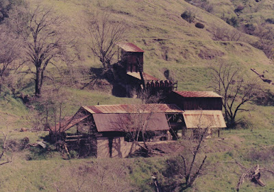
As we continued down the road, we came across this odd abandoned structure. This is the former headquarters of the Cloverdale Mining Company, which mined cinnabar for the production of quicksilver, or liquid mercury. Cinnabar, or mercury sulfide, was discovered in this area around 1863, and was being mined here by 1875. The Cloverdale Mining Company operated until about 1960.

1992 California Trip: San Francisco Cable Cars

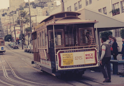
San Francisco Cable Car #25
Photo by Cliff West
The first cable car system was built in San Francisco in 1873. Cable car systems continued to grow until the 1890s, when electric streetcars began to arrive. The 1906 earthquake damaged many of the cable car systems, and they were replaced with streetcars. The city tried to eliminate all cable car systems in 1947, however the issue went to public referendum, and the people overwhelmingly supported the cable cars. Over the coming years, cable car lines were shut down one by one, until October 1, 1964, when the San Francisco cable cars became a National Historic Landmark. They are operated by the San Francisco Municipal Railway.

San Francisco Cable Cars #12 & #17
Photo by Cliff West
There are three operational cable car lines in San Francisco: the Powell & Mason line, the Powell & Hyde line, and the California Street line. These pictures were taken on the Powell & Mason line, at the turntable at the end of the line at Taylor Street. Though the cable cars look historic, they have all been extensively rebuilt in the late 20th century, though some original components are retained. Beginning in the 1960s, some entirely new streetcars have been built for the system, following the original designs.

1992 California Trip: Alcatraz

Alcatraz Island
Photo by Cliff West
On our family's California trip, after leaving the Towe Ford Museum in Sacramento on March 16, 1992, we headed straight for San Francisco and arrived just in time to catch the last outbound trip to Alcatraz Island.

Alcatraz Island
Photo by Cliff West
The first use of Alcatraz Island was as a US Military fort. Fort Alcatraz opened in December 1859. At the time, it was America's most powerful West Coast Defense. Throughout the 1800s, the fort was used as a military prison. In 1907, the fort was officially redesignated as a military prison. In 1933, the military prison closed. In 1934, the facility became part of the Federal prison system. Some of the more well-known prisoners held at Alcatraz were Al Capone, George "Machine Gun" Kelly and Robert Franklin Stroud, the "Birdman of Alcatraz." 

Alcatraz Island
Photo by Cliff West
The Federal prison was closed Thursday, March 21, 1963. It had housed a total of 1,545 prisoners; from 222 to 302 at one time. The island's facilities remained mostly abandoned (except for a few unofficial Indian occupations in the late 1960s) until 1972 when it fell under the jurisdiction of the National Parks Service.

Golden Gate Bridge
Photo by Cliff West
The Golden Gate Bridge (actually, its color is International Orange, not gold) is the most famous bridge designed by noted bridge designer Joseph B. Strauss, who designed over 100 bridges, including many of Chicago's lift bridges over the Chicago River, the operating mechanism for the Burnside Bridge in Portland, Oregon and the Lewis & Clark Bridge over the Columbia River between Rainier, Oregon and Longview, Washington. Construction began January 5, 1933, and when the bridge opened to pedestrian traffic May 27, 1937, it was ahead of schedule and under budget.  The bridge opened to auto traffic at noon the next day. The bridge is 9,266 feet long, and the main span (between the towers) is 4,200 feet. This was the longest suspension span in the world until the Verrazano Narrows Bridge in New York City (which is 60 feet longer) opened on November 21, 1964. Today it is the seventh-longest suspension span in the world. On average, 100,000 vehicles cross the bridge every day, and over 1 billion have crossed since it opened. The Golden Gate Bridge was named one of the Seven Wonders of the Modern World by the American Society of Civil Engineers on February 16, 1994.

San Francisco from Alcatraz Island
Photo by Cliff West
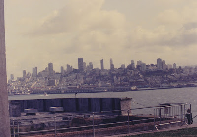
Here is a view of the San Francisco skyline from Alcatraz Island. The point of land at the northern tip of the San Francisco Peninsula was first colonized by the Spanish in 1776. At that time, the location was known as Nova Albion. It was renamed Yerba Buena by American Captain John Montgomery of the USS Portsmouth on July 9, 1846. It became San Francisco on January 30, 1847. With a population of about 776,000 people, San Francisco is the fourth largest city in the state of California. A total of about 7 million people live in the San Francisco metro area. The City of San Francisco and San Francisco County are considered a consolidated city-county. Essentially, the city and county are under a single, unified government that fills all the needs and takes all responsibilities of both city and county government.

Alcatraz Lighthouse
Photo by Cliff West
The first lighthouse in California was built here from 1852 to 1854. At 5:12 AM on the morning of April 18, 1906, an earthquake measuring 8.25 on the Richter scale shook San Francisco for 48 seconds, resulting in the deaths of over 3,000 people. The original lighthouse was damaged in the earthquake, and was replaced by this one in 1909. This lighthouse is 84 feet tall. It was automated in 1963. It contains a 200,000 candlepower beacon.

Alcatraz Administration Building
Photo by Cliff West
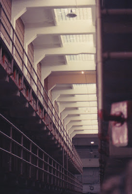
The Alcatraz cellhouse was built in 1912 on the foundations of the old Fort Alcatraz from the 1860s. Constructed at a cost of $250,000, the 500-foot long concrete building was reportedly the longest concrete building in the world at the time. In 1934, it was modernized at a cost of $260,000 for use as a federal prison. The cellhouse contains 378 cells, and has an administration building at one end.
Alcatraz Cellhouse
Photo by Cliff West
The cells are arranged in four three-tiered cellblocks, with no cell touching an exterior wall. Most prisoner were housed in B-Block or C-Block. A-Block was generally not used as it was never modernized from its military prison days. The worst prisoners found themselves in D-Block, which was used for solitary confinement and included the five isolation cells known as "The Hole." The corridors between the cellblocks were named. The main central corridor between B-Block and C-Block (pictured above) was called "Broadway," and connected to "Times Square," the corridor connecting the cellhouse to the dining hall. Other corridors were "Michigan Avenue" between A-Block and B-Block, "Park Avenue" between C-Block and the Library (adjacent to D-Block), "Sunrise Alley" on the far side of A-Block, and "Sunset Strip" on the far side of D-Block, 

Alcatraz Cell
Photo by Cliff West
Each of the 378 cell measured 9 feet deep by 5 feet wide by 7 feet high. The sparse cells contained only a bed, desk, washbasin and toilet. Hot water was not supplied to the washbasins until the 1960s.

Alcatraz Cell
Photo by Cliff West
Inside the cells, prisoners were allowed to have books (up to three from the prison library, plus 12 textbooks, a dictionary, and a bible), magazines, personal papers, a calendar and a musical instrument, and were provided with a mirror and radio headphones.

Alcatraz Infamous Inmates
Photo by Cliff West
This display lists some of the more well-known Alcatraz prisoners, with the crimes they were convicted of and their years at Alcatraz.

INFAMOUS INMATES

George "Machine Gun" Kelly
Kidnapping
1934-1951

Al "Scarface" Capone
Tax Evasion
1934-1939

Robert Stroud "Birdman of Alcatraz"
Manslaughter, Murder
1942-1959

Meyer "Mickey" Cohen
Racketeering
1961-1962

Alvin "Creepy" Karpis
Kidnapping, Bank Robbery
1936-1962

Arthur "Doc" Barker
Kidnapping
1935-1939

"The inmates of Alcatraz were numerous as far as public enemies went."
-former Alcatraz convict, 1941-1953

Alcatraz Dining Hall
Photo by Cliff West
The dining hall was connected to the cellhouse by the "Times Square" corridor. The dining room seated over 250 people. Prisoners, guards and officials all dined together. Prisoners were allowed to eat all they wanted during their 20 minute mealtimes, but they had to eat all they took. All of the food was prepared by inmates and was reportedly the best in the entire US prison system.
Alcatraz Dining Hall & Cellhouse
Photo by Cliff West
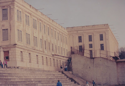
In this picture, the dining hall is on the left, and the cellhouse is on the right, attached to it. In addition to the dining hall itself, the dining hall building also contained the kitchen. On the top floor was the hospital, as well as an auditorium where movies were screened for the inmates on weekends.


Alcatraz Recreation Yard
Photo by Cliff West
The recreation yard was adjacent to the dining hall. surrounded by a high concrete wall topped with a chain-link fence. Originally a dirt-covered yard when the federal prison opened in 1934, the recreation yard was paved in 1936. 

Alcatraz Recreation Yard
Photo by Cliff West
Inmates were allowed in the yard for up to five hours on Saturdays, Sundays and holidays, with some prisoners also rewarded with short yard breaks on weekdays. Prisoners played baseball, softball, basketball, and chess. 
Alcatraz Model Industries Building
Photo by Cliff West
The oddly-shaped Model Industries Building was originally built by the U.S. Military. It contained the laundry as well as workshops for inmates to work in. The guard tower on the roof was added in June 1936, but has disappeared since this picture was taken.

Also visible in the foreground of this picture is the roof of the New Industries Building. This 306-foot long two-story building was constructed in 1939 at a cost of $186,000. The ground floor contained a clothing factory, a dry cleaning plant, a furniture plant, a brush factory, and an office, while the second floor housed the laundry. Prisoners earned money working in these facilities.

San Francisco from Alcatraz Island
Photo by Cliff West
This view of San Francisco from Alcatraz shows the distance across the bay that prevented escaping to freedom. While a few inmates did manage to get off the island, none are known to have survived the watery expanse.

Golden Gate Bridge
Photo by Cliff West
Here is another view of the Golden Gate Bridge from Alcatraz Island. The island's location in San Francisco Bay offers views of both the Golden Gate Bridge and the San Francisco-Oakland Bay Bridge.
San Francisco-Oakland Bay Bridge
Photo by Cliff West
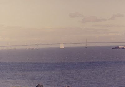
This is the San Francisco-Oakland Bay Bridge. Built from July 9, 1933 to November 12, 1936, the double-deck connection of Interstate 80 between Oakland and San Francisco is actually two separate bridges. The 9,260-foot West Span (pictured) is two suspension bridges connected end-to-end at a man-made anchor point. The towers of the West Span are 526 feet tall, and the bridge has 220 feet of vertical clearance above the bay. The 10,176-foot East Span (not pictured) is a combination of cantilever beams and trusses. The two spans meet at Yerba Buena Island, where they are connected by a 1,700-foot tunnel. The tunnel, at 76 feet wide and 56 feet high, is the largest-diameter bore in the world. On average, 280,000 vehicles make this crossing every day.

On October 17, 1989, the Loma Prieta earthquake caused a 50-foot section of the upper deck of the East Span to collapse onto the lower deck. The bridge was closed for a month for repairs. Today, a new East Span has been built.

Alcatraz Wharf Guard Tower
Photo by Cliff West
This is the guard tower at the Alcatraz Wharf. From this tower, guards could watch over every vessel that came and went. On the right is the corner of Building 64, which was originally built in 1905 on the site of an old Army barracks from the 1860s. Originally used as barracks for the military guards from 1906 to 1933, it was used as residential apartments for the federal guards and other prison personnel when Alcatraz became a federal prison. Treasure Island and Oakland are visible in the distance.

Red & White Fleet Royal Star
Photo by Cliff West
Here is the Red & White Fleet's passenger ferry Royal Star at the Alcatraz Wharf boarding passengers for the trip back to San Francisco. The Royal Star remains in service on San Francisco Bay, but is now operated by the Blue & Gold Fleet.

Coit Tower & TransAmerica Pyramid
Photo by Cliff West
Here is a view of San Francisco from the deck of the Royal Star. The Coit Tower (center), located on the top of Telegraph Hill, is 210 feet tall and was completed in 1933. Its Art Deco design resembles the nozzle of a fire hose. Coit Tower was built from funds willed to San Francisco by firefighter admirer and supporter Elizabeth Wyche "Lillie" Hitchcock-Coit in 1929. The distinctive TransAmerica Pyramid (far right), at 600 Montgomery Street, was built from 1969 to 1972. It is 853 feet tall, and its 48 floors house a total of 530,000 square feet of office space.