| Echo Lake Dam in Burlington, Wisconsin, on November 21, 2001 |
| Wisconsin Central railroad bridge over Echo Lake in Burlington, Wisconsin, on November 21, 2001 |
| Echo Lake Dam in Burlington, Wisconsin, on November 21, 2001 |
| Wisconsin Central railroad bridge over Echo Lake in Burlington, Wisconsin, on November 21, 2001 |
…Continued from Oregon Holocaust Memorial.
Reservoir #3 on February 27, 2010
Washington Park contains two reservoirs for Portland's drinking water.
Reservoir #3 on February 15, 2010
Reservoir #3 was built in 1894. It is 49 feet deep and holds 16.4 million gallons of water.
Reservoir #3 on February 15, 2010
Federal drinking water regulations require that Portland replace its open reservoirs with covered reservoirs.
Reservoir #3 on February 15, 2010
A covered reservoir will be built in place of the current open Reservoir #3, with a reflecting pool on top to preserve the original appearance.
Reservoir #3 Gatehouse on February 15, 2010
This is the gatehouse for Reservoir #3. The oval-shaped structure displays the high level of architectural detail and workmanship that even the most utilitarian buildings received back in 1894.
Reservoir #4 on February 15, 2010
From the walkway around Reservoir #3 is this view of the similar Reservoir #4, also built in 1894.
Reservoir #4 on February 15, 2010
The water in Reservoirs #3 & #4 is between 35 and 50 degrees and arrives through a gravity-fed system primarily from Reservoir #5 at Mt. Tabor Park in Southeast Portland.
View of Vista Bridge & Downtown Portland on February 27, 2010
From along Sherwood Boulevard above the reservoirs there are a few spots with views of downtown Portland, including the US Bancorp Tower, and the Vista Avenue Viaduct.
View of Vista Bridge & Downtown Portland on February 27, 2010
View of US Bancorp Tower on February 27, 2010
View of Vista Bridge & Downtown Portland on February 27, 2010
Exposed Tree Roots in Washington Park on February 27, 2010
There are many trails running through Washington Park. I saw this tree with its roots exposed along the Multnomah Athletic Club (MAC) Trail.
Continue to International Rose Test Garden…
The Dalles Dam on June 10, 2009
The Dalles Dam was built by the U.S. Army Corps of Engineers in the mid-1950s. It was completed on March 10, 1957 submerging the rapids known as the dalles, Celilo Falls, traditional Native American fishing sites, and old locks once used for portage beneath the 24-mile-long Lake Celilo.
The Dalles Dam on June 10, 2009
The dam is 260 feet high and 8,875 feet long, of which 1,380 feet is made up of 23 spillway gates. The dam provides irrigation and flood control, and its 22 turbines produce 1,800 megawatts of electricity.
The Dalles Dam on June 10, 2009
A single-lift lock on the Washington side, 86 feet wide and 650 feet long, provides easy navigation.
The Dalles Dam on June 10, 2009
Related Link:
The Dalles Dam as the U.S. Army Corps of Engineers
Historical Photos:
The Dalles Dam (CGDC)
The Dalles Dam, September 15, 1958 (SPL)
The Dalles Dam, September 30, 1958 (SPL)
Continue to 90: Oregon Motor Motel Sign…
Kellogg Creek Dam on September 27, 2008
Kellogg Creek was originally called Cold Creek by the native people who lived in this area.
Kellogg Creek Dam on September 27, 2008
The land at the mouth of the creek was purchased by Joseph Kellogg, one of Milwaukie’s founders, who renamed the creek Kellogg Creek.
Kellogg Creek Dam on September 27, 2008
Joseph Kellogg originally built the Kellogg Creek Dam in 1858 to power the Standard Mill, the first flour mill in the northwest. The mill was on the south shore of Kellogg Creek where it flows into the Willamette River.
Kellogg Creek Dam on September 27, 2008
The dam created Kellogg Lake behind it, which was used as a log pond.
Kellogg Creek Dam on September 27, 2008
The Kellogg Creek Dam was also used to power a sawmill and a shingle factory.
Kellogg Creek Dam on September 27, 2008
The Standard flour mill was shut down after 1879. Its machinery was removed and the structure was abandoned. The flour mill collapsed into the Willamette River in 1903.
Kellogg Creek Dam on September 27, 2008
The Kellogg Creek Dam has been rebuilt numerous times. The current dam was built in the late 1930s when the highway was built.
Kellogg Creek Dam on September 27, 2008
The Kellogg Creek Dam was a barrier to fish until a fish ladder was added in 1954.
Kellogg Creek Dam on September 27, 2008
The current Kellogg Creek Dam is incorporated into the bridge for McLoughlin Boulevard (Highway 99E).
Kellogg Creek Dam on September 27, 2008
Though the highway has been widened since then, a section of original railing remains in place on the east side of the bridge.
Continue to 4: Willamette River Railroad Bridge…
2100 Ferry Street SE
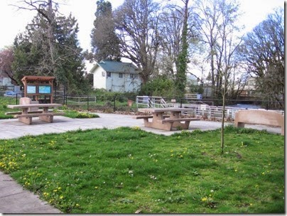
Mill Race Park on March 25, 2007
Mill Race Park is located on the bank of Mill Creek where the millrace is separated from the creek by the Waller Dam. This small park is maintained by the Salem Parks Foundation and the Southeast Salem Neighborhood Association.
Mill Creek behind Waller Dam on March 25, 2007
Mill Creek's watershed originally consisted of about 209 miles of streams, but in 1856, the Salem Ditch was constructed to divert flow from the North Santiam River to Mill Creek to provide a constant supply of water power for Salem industry.
In 1864, the Waller Dam was built to divert water from Mill Creek to a millrace, that would allow more industries to have access to water power.
The Waller Dam creates a five-foot change in the water level of Mill Creek.
The dam includes a spill gate that can be opened during times of high-water flow to keep the water level behind the dam low.
Waller Dam Spill Gate & Fish Ladder on March 25, 2007
Next to the spill gate is a fish ladder that allows the fish that call Mill Creek home to get past it.
Waller Dam Spill Gate on March 25, 2007
Mill Race at Mill Race Park on March 25, 2007
The millrace is over one mile in length and passes through the grounds of Willamette University and two downtown parks, before emptying into Pringle Creek to the south.
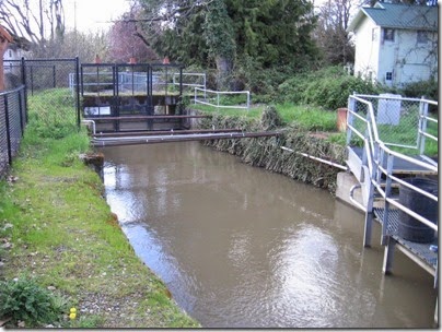
Mill Race Control Gates on March 25, 2007
The flow of water in the millrace is regulated by the control gates located here.
Map of the area around the Waller Dam
The Salem area is home to a variety of fish species that can be found in Mill Creek. These fish include Sculpin, Speckled Dace, Redside Shiners, and Northern Pikeminnow, as well as three species of salmonid fish: the Chinook Salmon, the Steelhead and the Cutthroat Trout.
The Chinook Salmon (Oncorhynchus tshawytscha) is the least abundant of all the salmon species but is also the largest, sometimes reaching 100 pounds or more. Chinook salmon lay their eggs, or spawn, on gravel bars in the Willamette Rivers and its tributaries between August and October. The female digs a redd, or nest, in the gravel and lays about 5.000 eggs, which are immediately fertilized by the male. Within a few days of spawning, the adults die. In two to four months, the eggs hatch, and the juvenile fish spend several months near the place they were born, feeding and growing larger until the spring, when they migrate down the Willamette and Columbia Rivers to the Pacific Ocean. The fish live in the ocean for three to five years, migrating as far north as the Bering Sea before returning to where they were born to spawn, completing the cycle.
Most Chinook Salmon in Mill Creek return from the ocean in the spring. These Spring Chinook are native to the area. The entire Upper Willamette River system had no native Fall Chinook. Fall Chinook fingerlings from state hatcheries were first planted in Mill Creek by the Oregon Department of Fish and Wildlife in 1968. The first adult Fall Chinook returned to Mill Creek to spawn in September and October of 1970. The early runs averaged 6,000 fish annually.
Sign about Fall Chinook at the Waller Dam on March 25, 2007
A sign was posted on the fence on the opposite side of Mill Creek from Mill Race Park by the Oregon Department of Fish & Wildlife explaining the program when Fall Chinook were still being planted in Mill Creek and it remains there (as of 2007), largely forgotten. Fall Chinook are no longer stocked in Mill Creek, but a few Fall Chinook, descendants of those planted fingerlings, occasionally return to spawn.
| Spring Chinook (Native) | Fall Chinook (Introduced) | |
| Juveniles | Stay in the Willamette and its tributaries for several months. | Stay in the Willamette and its tributaries for several months. |
| Juvenile to Adult Phase | 3-5 Years in the Ocean | 3-5 Years in the Ocean |
| Migrate from the Ocean | In Spring | In Fall |
| Spawn | Fall | Fall |
The Steelhead Trout (Oncorhynchus mykiss) can be found migrating throughout the year. Winter Steelhead are native to the area, leaving the ocean in the winter and swimming up the Willamette River in March and April to spawn in the spring, but Summer Steelhead that leave the ocean during the spring & summer and spawn in the winter have been introduced. Steelhead spawn in the area they were originally born, but do not die after spawning and may return to the ocean and come back to spawn again. Young Steelhead rear in the Willamette River and tributaries like Mill Creek for a year or two before migrating to the Pacific Ocean, where they live for another year or two before returning to spawn.
| Winter Steelhead | Summer Steelhead | |
| Juveniles | Stay in the Willamette and its tributaries for 1-2 years and then migrate to the ocean. | Stay in the Willamette and its tributaries for 1-2 years and then migrate to the ocean. |
| Juvenile to Adult Phase | 1-2 Years in the Ocean | 1-2 Years in the Ocean |
| Migrate from the Ocean | In Winter | In Spring and Summer |
| Spawn | March-May and may return to the ocean. | In winter and may return to the ocean. |
Although Cutthroat Trout (Oncorhynchus clarki clarki) in some areas do migrate to the Pacific Ocean, the Cutthroat in the Salem area cannot because Willamette Falls in Oregon City acts as a natural barrier to them. Fluvial Cutthroat spawn in streams like Mill Creek and migrate to larger rivers like the Willamette to fed and grow, while Resident Cutthroat live their entire lives in the same stream.
| Cutthroat Trout (Native) | |
| Juveniles | Fluvial – rear in large rivers, then migrate to smaller streams to spawn. |
| Juvenile to Adult Phase | 3 Years |
| Migrate from the Ocean | Our cutthroat trout cannot migrate past Oregon City due to the Willamette Falls and are thus landlocked. |
| Spawn | In Winter |
Mill Race Fish Screen on March 25, 2007
Because the artificial millrace is not an appropriate habitat for fish, the City of Salem installed a fish screen at the entrance to the millrace during the summer of 2003 to keep fish like the endangered Chinook Salmon and Steelhead from entering it. The openings in the screen are small enough that even newborn fish are unable to enter the millrace.
Mill Race Fish Screen on March 25, 2007
Adjustable tuning vanes behind the screen regulate the water flow to prevent fish from being trapped on the screen, and an automatic system of high-pressure nozzles keeps the screen clear of debris. A trash rack ahead of the screen prevents large floating debris from damaging the screen.
Waller Dam Fish Ladder on March 25, 2007
When the fish screen was installed at the entrance to the millrace, the Waller Dam's fish ladder was modified to make it easier for fish to go through it. The number of pools in the ladder was increased from 5 to 7 to lower the jump height between pools to about 8 inches. The pools are about 3 feet deep, and redesigned weirs ensure water always flows through them.
Waller Dam Fish Ladder on March 25, 2007
Additional Links:
Mill Race Dam at Discover-Neighborhood-History
Waller Dam from Mill Race Park on March 25, 2007
Continue to 4: Willamette University…
Located 25 highway miles east of Berne, in the Tumwater Canyon, this dam was built by the Great Northern Railway to produce the electricity for the electric locomotives that pulled trains through both Cascade Tunnels.
The Great Northern mainline went down Tumwater Canyon and past this plant until 1928, when the new Chumstick Line was opened that bypassed the canyon and was shorter and straighter with less grades.
The city of Leavenworth was also bypassed, leaving the town virtually isolated until U. S. Highway 2 was built through Tumwater Canyon, directly on the roadbed of the Great Northern's original route, where it remains today.
A sign at the dam explains its historical significance.
HISTORIC TUMWATER DAM
The Tumwater Hydroelectric Project was constructed from 1907 to 1909. At that time, the hydroelectric project was the largest west of Niagara Falls. The project was constructed by the Great Northern Railway Company to produce power for electric locomotives traveling through the old Cascade Tunnel on the Stevens Pass route.
Electrification of the three miles of the line brought an end to the serious smoke and gas conditions in the tunnel resulting from the coal burning locomotives. Four 100-ton electric locomotives were in service on the trolley line to pull passenger and freight trains through the tunnel, which was abandoned in 1929 upon construction of a new eight-mile-long Cascade Tunnel. The locomotives were the first in the United States to utilize the principle of regenerative braking, returning power to the lines on the downhill grade.
From the Tumwater Dam, water was delivered through a penstock to a powerhouse over two miles downstream. A bridge was constructed across the river to allow railroad access to the dam construction site. The bridge was then utilized to carry the penstock to the powerhouse. The bridge still stands, and serves as a link to the old penstock route. The powerhouse was a concrete and brick structure that housed three waterwheels and three 2,000 kilowatt generators.
The Tumwater Hydroelectric Project was closed in 1956. By that time, the railroad had converted to diesel engines. The project was purchased by the Chelan County public Utility District in 1957. The powerhouse and related generating facilities were subsequently removed.
The Tumwater Dam is now equipped with modern fish passage facilities to assist adult salmon and steelhead returning to their spawning grounds.
HISTORIC PROJECT STATISTICS
DAM
Groundbreaking............July 6, 1907
Length...........................400 Feet
Height...........................23 Feet
Construction Cost.......$100,000
Fishway........................Newly Constructed 1987
HEAD..............................200 Feet
PENSTOCK
Material.......................Wood & Steel
Length.........................11,654 Feet
Diameter.....................8.5 Feet
SURGE TANK
Height.........................210 Feet
Capacity......................1 Million Gallons
POWER HOUSE
Generators..................Three, 2,000 kilowatts each 25 Cycle, A.C.
Turbines......................Three, Francis type 4,000 horsepower each
Historical Photo:
Great Northern Tumwater Powerhouse, circa 1908 (UW)
East of Leavenworth, Highway 2 meets up with the railroad again, which returns to its original alignment through Wenatchee to Spokane and beyond. From this point on, there isn't much of historical interest to non-rail enthusiasts along the route for quite a distance beyond Stevens Pass, so that concludes this expedition.
This concludes the original content of my Stevens Pass PLACES page. To see any additional blog entries about Stevens Pass, click on the Stevens Pass label.